
1645
Fort Royall and Menmend
“They decided to build three small forts or surveillance posts at
strategic locations on the colony's
frontier. In February 1645 the Grand Assembly ordered the construction of
forts at three remote
locations that were considered critical to the colony's defense: Fort Charles
at the falls of the James River, Fort James
on the Chickahominy River at Moysenac, [7] and Fort Royall on the Pamunkey River near Manquin Creek. At Fort
Royall, in the Pamunkeys' heartland,
armed men were to maintain vigilance over the tribe that had played a major
role in both uprisings. …
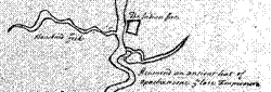
Anthony Langston's map, prepared in ca. 1662, reveals that several
sites in the eastern part of Pamunkey
Neck continued to be associated with Native occupation. Shown prominently was "Menmend, an ancient seat of Opachancone
[Opechancanough] ye late Emperour." It was located on a large island near Carter's Landing, east of
Manquin Creek. “
Martha MacCartney

Fort
Royal
Moncuin
Creek
Remnants of Manskin Indians probably still living on Island Field. Notice the label is in past tense.


Anthony Langstrom 1662