
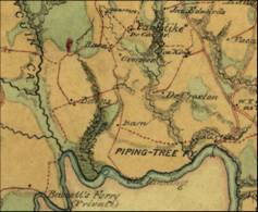
Blackford 1865
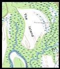
Imaginary Island at mouth of Dam Creek

In
1865 during the Civil War, Lewis Blackford draws a very detailed
map of the Island. This is by far the most accurate
map of the period.
By this time, the swamp north of the
island open farmland has converted to fields by
“land reclamation” and the distinctive shape
of the island is almost lost.
Interestingly,
he cannot overcome all the past drawings with the floating
round islands and actually draws one in the middle
of the river because he cannot find an
island in the river. He seems to be relying off the
Fry and Chesney maps. He must have felt pensive about
drawing it for he drew it lightly with green ink.