
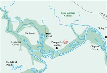

2006 MPRA Map
2006 Mataponi and Pamunky River Association
creates a set of water trail maps that also show the
Horseshoe Island. This map is clearly derived from the
older USGS Nautical maps.
The “Island”
Pampatike Creek
Dam Creek
Horse Shoe Island drawn as island in middle of river
Dam Creek is mixed up with Pampatike Creek (understandable). In
the 1700s, Pampatike Creek was known and Goodwin’s Creek. From 1835 to 1915, Pampatike Creek was renamed “Dam” creek because it had a tide gate. In
the 1930’s after the gate was long gone, the remnant mouth of Pampatike creek was mistakenly renamed Dam Creek by the USGS.
