
John Smiths Map show a series of
Islands
Smith
makes the engraving in 1624 of his 1606 memories to have
the upper Pamunkey river filled with little
islands.
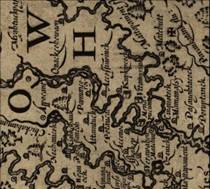

1608 John Smith
John Smith
explored the Pamunkey river in a small boat
called a shallop. They travel at high tide and anywhere
he could paddle a canoe back out to the river,
he marks as an island. So he draws many
islands floating in the middle of the river in his
map created in 1624 Because the river has so many
similar turns, they simply count the number
of island they encounter.

