
1865 Civil War Map and location of
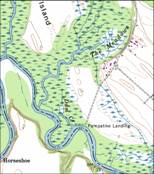
Dam Creek Location
•“beginning at the mouth
of Goddin’s Creek or swamp, a little below Goddin’s
Island (this creek is now called the dam creek and has had a flood
gate at its mouth for many years, now out of repair, and runs between
the island and the Shop Spring meadow fields on “Pampatike”)” (1915
Thomas N Carter Letter)
•Pampatike
Creek was sometimes know as Goddins Creek at this time.
•It is
drawn as “Pampatike Swamp” in the 1865 Blackford map
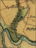

Lewis Blackford’s 1865 Civil War map shows Goodwins
Creek in it’s original position even though it was gone for 30 years
2 Separate Creeks
1 Single Creek

Flood gate
Shop Spring Meadows
field is now a swamp labeled
“The Meadows”


“Pampatike
Swamp”