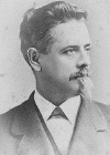
Col. Thomas H. Carter

Pampatike Farm
History by
William Tyler
Pampatike Farm lies along the Pamunkey River just two miles South East of the intersection of Rt. 360 and the Pamunkey River in King William County, Virginia. The Farm has a long and varied history.
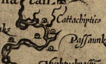 It was a Indian village called Cattachiptico and was drawn
on John Smiths Map of the new world in 1609. It was then transformed
into Opechancanough's fortress and newly identified documents
show the possibility that it was the location where John Smith grabbed
Opechancanough by the hair and put a pistol to his head in order to
escape an ambush.
It was a Indian village called Cattachiptico and was drawn
on John Smiths Map of the new world in 1609. It was then transformed
into Opechancanough's fortress and newly identified documents
show the possibility that it was the location where John Smith grabbed
Opechancanough by the hair and put a pistol to his head in order to
escape an ambush.
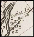 In the 1600 through
the mid 1700's, it was the location of sub-tribe of the Pamunkey
Indians called the Manskin Indians who were accidentally erased from
history when their name got confused with the Manakin Indians just up
river.
In the 1600 through
the mid 1700's, it was the location of sub-tribe of the Pamunkey
Indians called the Manskin Indians who were accidentally erased from
history when their name got confused with the Manakin Indians just up
river.
 It was sold by the
Pamunkey Indian Queen and by 1744 it became part of the the Carter
Family empire. By the early 1800s, Hill Carter lived at Shirley
Plantation and his brother, Thomas N. Carter lived at Pampatike.
In 1820 and 30s both Hill and Thomas Carter experimented with an almost
forgotten farming technology called land reclamation where the swamps
were diked and corn and wheat was grown.
It was sold by the
Pamunkey Indian Queen and by 1744 it became part of the the Carter
Family empire. By the early 1800s, Hill Carter lived at Shirley
Plantation and his brother, Thomas N. Carter lived at Pampatike.
In 1820 and 30s both Hill and Thomas Carter experimented with an almost
forgotten farming technology called land reclamation where the swamps
were diked and corn and wheat was grown. 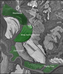 This was a massive transformation of the land where over
500 acres of land were reclaimed. The swamps were diked and all creeks
on the property were re-routed to reduce water from the newly made
"blacklands" or "meadows." The dikes were abandoned after the civil war
and the land returned back to natural swamps.
This was a massive transformation of the land where over
500 acres of land were reclaimed. The swamps were diked and all creeks
on the property were re-routed to reduce water from the newly made
"blacklands" or "meadows." The dikes were abandoned after the civil war
and the land returned back to natural swamps.
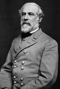 During the Civil War
Union forces camped on the property and Col. Thomas H. Carter was often
visited by his first cousin General Robert E. Lee.
During the Civil War
Union forces camped on the property and Col. Thomas H. Carter was often
visited by his first cousin General Robert E. Lee.
The house was burned at
about
1900 and was rebuilt a few years later and is now Pampatike Organic Farm which
raises vegetables, herbs, flowers, free-ranging chickens for eggs,
other free-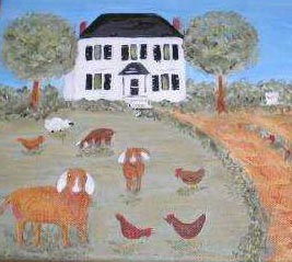 ranging poultry (guineas,
peafowl, Royal Palm turkey), and purebred Nubian dairy goats using organic farming practices for all. Kid goats are raised as
breeders for export and domestic sales.
ranging poultry (guineas,
peafowl, Royal Palm turkey), and purebred Nubian dairy goats using organic farming practices for all. Kid goats are raised as
breeders for export and domestic sales.
 The swamp and fields
of the farm are owned by Frank Townsend and my Dad, Harrison Tyler, and
are used for corn, bean and wheat farming. The farm also has wonderful
duck, goose and turkey hunting.
The swamp and fields
of the farm are owned by Frank Townsend and my Dad, Harrison Tyler, and
are used for corn, bean and wheat farming. The farm also has wonderful
duck, goose and turkey hunting.
I have completed this historical research and want to make it available to all interested. I would also appreciate and new documents or related information so I can add it to this site.
Historical Documents
Thomas N.
Carter Letter
This is a letter written in 1915 by Thomas N. Carter, grandson of
Thomas N. Carter who built the dikes. It has the best first line I have
ever seen. "I think it the duty of every man, before his memory begins
to fail, to set down in writing, for the benefit of his children, what
he knows about his family." He talks about the history of the land, who
built the dikes, and also has some touching and amusing Civil War
stories.
This is the Rosetta Stone of land reclamation in Virginia in the early 1800s. Hill Carter at Shirley Plantation wrote this for Edmund Ruffin's magazine "The Farmers Register" and it details everything you ever want to know about dike construction. The entire East Coast of the United States were nearly clear cut. Most fields had stopped producing. An agricultural crisis gripped the United States. The Carters stepped up to the plate in Virginia promoting "land reclaimation," and Edmund Ruffin promoted "marling." Both practices were dropped at the end of the civil war with the the loss of cheap slave labor and the chemical synthesis of nitrogen for fertilizer.
Shirley Sinking Swamp Article
This is the book end to the first article and describes the failure of the diked swamps due to sinking. The cost of repairing the sinking swamps was too high and he eventually attempted to plant trees in the swamp which had then turned into a grassy marsh as it remains today.
Draft of York River -W Pictures
Martha McCartney was prompted to do research on the Pamunkey River when the Newport News Water Reservoir was first announced. She found a map of the Pamunkey River in archives in England, but with no date or author it had been of little use. Through hand writing analysis she identified the document as being written by Anthony Langstrom in 1662. Landstrom identifies the Island field on Pampatike as the headquarters of Opechancanough.
Deep Water -Pampatike
Deep Water is a book about the houses along the Pamunky River and was written By Steven A. Colvin. It has a concise history of both Pampatike and Piping Tree Ferry.
Deep Water - Manskin Lodge
A History of Manskin Lodge, just up river from Pampatike. It mentions the location as a "slight peninsula, known as Manskin Neck, after a tribe of Indians of that name."
Land, Labor and Reform at Shirley
Robert James Teagle wrote this thesis paper while at Va Tech. There are at least 40 pages on the effects of the diking project at Shirley on the lives of the slaves.
R. E. Lee A Biography
Robert E. Lee grew up at Shirley Plantation and was first cousin to Col. Thomas H. Carter who lived at Pampatike. This details some of Lee's visits to Pampatike.
Woody vs
Abrams Supreme Court Decision
Woody vs
Abrams Defendants Testimony
Woody vs
Abrams Plantiff Testimony
When you combine the fact that King William Court House was burned in
1887 and all the creeks at Pampatike have been moved by land
reclamation, you have a recipe for property line disputes. This is a
case where Monquin creek had moved to a new location and 1920 and it
went all the way to the Supreme Court. The final ruling affirmed
that the creek had been moved by human interference and the old creek
bed was, and is today, the true property line. But imbedded in the
testimony are descriptions of the dikes on Monquin Creek and the
"blacklands", which was the name for the diked swamp used for growing
corn and wheat.
THE SEARCH FOR ELUSIVE VIRGINIA COASTAL PLAIN BURIAL
MOUNDS
Extensive local oral history had always told stories of the mysterious
mounds in the swamp next to the Island field at Pampatike as being
Indian burial mounds. Randy Turner does core samples and determines the
mounds were of geologic creation.
Presentations
These are image based presentation attempting to visually show the history of Pampatike. They involve extensive progression of maps combined with bits of text pulled from many sources to create the complete history of Pampatike. I initially intended to write a text document, but most of the clues I had were map based, so I chose to visually represent the ideas with PowerPoint presentations. We live in a changing world and right this minute libraries all over the world are putting high resolution versions of historic maps online. This allows arm-chair archeologists like me have access to vast amounts information all sorted, googled and scanned. If one focus on a small niche, like 4 miles of a river, then all sorts of new conclusions can jump out of the research.
Indian Burial Mounds
Burial mounds located near Pampatike are proven to be of geologic
origin.
Upper
Pamunkey River Cartography
Each century the cartographic definition of what makes an island
changes how "The Island" is depicted over the past 400 years- and
nobody gets it right to this day!
John Smiths Fight
with Opechancanough
John Smith has a run-in with Opechancanough and ends up grabbing him by
the hair and putting a pistol to his head. New information from the
Langstrom map combined with re-interpretation of island locations and
sailing distances points to the location of this battle taking place on
"The Island."
Manskin Indians
lived on Island Field
A sister or subset tribe of the Pamunkey Indians live on or near "The
Island" and have been lost to history due to confusion with the Monocan
Indians living up-river
Pampatike
Land Reclamation
The Carter family at Shirley Plantation square off with Edmund Ruffin
to find a way to save agriculture in the eastern US in the early
1800's: Blackland farming vs Marling. Complete terraforming of the
swamps on a vast scale are the hallmarks of this grand, failed
experiment in agriculture.
Monquin Creek
History
The location of a creek relocated by the Carters during land
reclamation creates property line disputes that make their way all the
way to the Supreme Court.
Island
Field Name Over Time
Changing names of "The Island" as it winds its way through time.
Cartographic
Errors
Cartographer make repeatedly make errors that can be categorized.
Listed are a number of example in the Moncuin Creek area.
Manskin Cartographic
Temporal Memory
The Manskin tribe lived on the Island field from 1608 to the mid 1660s,
yet all most of the maps show them on Guttins Isle from 1670 to 1754.
How can the Island be named after the Goodwin Family when the Indians
should be living on it? This inconsistancy happened because of their
infamy and demise after the massacre of 1644.
Youghtanund
Tribe became Manskin
The Youghtanund Indians were a well documented tribe of Indians that
dissappear from maps at exactly the same time that the Manskins Indians
appear in maps just across the river.